The Harbor Commission is a toxic workplace.
San Mateo County Harbor District
By Sabrina Brennan
It’s time to accept that coastal California is shrinking. A new study from the Union of Concerned Scientists predicts chronic Bay Area flooding from rising seas as early as 2060. “Cities around the San Francisco Bay will begin to experience more frequent and disruptive flooding in the coming decades and will have to make tough decisions around whether to defend existing homes and businesses or to retreat,” said Erika Spanger-Siegfried, senior analyst in the Climate and Energy Program at UCS and a report author.
The Pacific Institute calculates that San Mateo County will lose more in property value than any other county in the state. Property damage in the county is estimated to be in the region of $39 billion, with sea level rise projected to affect more than 100,000 residents.
In July, the Mercury News reported that San Mateo and Marin Counties and the City of Imperial Beach filed a lawsuit in Marin County Superior Court. The suit alleges that, “major corporate members of the fossil fuel industry, have known for nearly a half century that unrestricted production and use of their fossil fuel products creates greenhouse gas pollution that warms the planet and changes climate.”
The suit argues that 37 oil, gas and coal companies actively worked to “discredit the growing body of publicly available scientific evidence and persistently create doubt” in “a coordinated, multi-front effort.”
The suit asserts what many of us already accept as fact, that fossil fuel companies “have promoted and profited from a massive increase in the extraction and consumption of oil, coal and natural gas, which has in turn caused an enormous, foreseeable, and avoidable increase in global greenhouse gas pollution.”
Armoring the coast and building levees in the Bay will be an unimaginably expensive public undertaking, and that doesn’t include relocating highways, railways, airports, and other critical infrastructure.
Last month, the Guardian reported that Mayor Serge Dedina said that up to 30% of Imperial Beach could be affected by climate change. “As the lowest-income, highest poverty-rate city in San Diego County, we have no capacity to pay for the extensive adaptation measures.” Within 15 years flooding could affect tens of thousands of Marin County residents and cause upwards of $15.5 billion in property damage. “This lawsuit is intended to shift those costs back where they belong – on the fossil fuel companies,” says Marin County supervisor Kate Sears.
A well-funded army of lawyers is organizing to defend deep-pocketed multinationals that include San Ramon-based Chevron, ExxonMobil, BP, and Shell, while at the same time the Plaintiffs continue to approve new development within sea level rise inundation areas. These new developments will add to the already huge cost of removal and replacement of hospitals, schools, airports, fire stations, police stations, ports, roads, railroad tracks, pump stations, sewage treatment facilities, power plants, utilities, hazardous material sites, and more.
As communities become dependent on costly levee systems to stay dry, and climate projections continue to worsen, we will soon be spending exponentially larger sums of money to protect development now being built in inundation zones. One good example is the 8-mile long levee do-over in Foster City that is now budgeted for $90 million. That levee must be rebuilt three feet higher or residents will be required to buy costly flood insurance.
In addition to suing oil companies our elected representatives have a responsibility to protect the public from the huge financial burden sea level rise will bring to coastal California. They can do this by using their powers to implement policies that limit development in known inundation areas and to prohibit future shoreline armoring in favor or wetland restoration.
Suing the fossil fuel companies is a great start to holding those responsible for the coming disaster to account, but that must only be a beginning. Without common sense and practical pragmatic legislating any legal action becomes nothing more than a show. If they really want to leave a lasting legacy current local legislative bodies must show through use of their powers that they have an understanding that development in inundation zones is literally pouring money down the drain. Anything less is going to be an expensive and complex disaster.
Published in the Daily Journal on Aug 14, 2017 and on the Everything South City website. Published in the Half Moon Bay Review on Aug 23, 2017.

Trash Dumps and the Hidden History of the Bay Shoreline
First there were marshes; then there were dumps. The dumps were eventually turned into regulated landfills, and the landfills into shoreline parks.
The Oyster Point Landfill is a closed, unlined Class III landfill that was in operation from 1956 to 1970. Prior to 1956, what would become the Oyster Point Landfill area consisted of tidal marshlands and upland soils and bedrock.
Between 1956 and 1970, the City of South San Francisco leased the site (approximately 57 acres) to South San Francisco Scavenger Company.
In 1956, Scavenger began disposal operations at the landfill. Initially, municipal solid waste was disposed of on the ground and burned. This activity ended in 1957 following the enactment of laws prohibiting open air burning of rubbish in the Bay Area. To address the new air quality restrictions South City and Scavenger established a solid waste disposal site on the submerged lands just east of the original Oyster Point.
The landfill was developed in three phases. Filling of the first section began in 1957 and was completed by late 1961. The first area to be filled extended into the Bay about 1,500 feet eastward from the original bluff. Scavenger placed waste directly into the tidelands and used a wire fence to control the discharge of solids into the Bay due to tidal action. Waste disposal operations eventually resulted in the relocation of the shoreline approximately 3,000 feet to the east of the pre-landfill shoreline.
The landfill material consists of up to 45 feet of poorly compacted municipal and industrial waste. Typical waste found within the landfill includes the following: chemicals, drums, paper, cardboard, organic matter, wood, glass, metal, rubber, rocks, concrete, and other materials. The base of the landfill material has been compressed into, and mixed with, the upper part of the Bay Mud. The volume of waste in the landfill is approximately 2.5 million cubic yards and total tonnage of this material is approximately 1.4 million tons. This volume of waste would cover a football field almost to the height of the Empire State Building.
Beginning in 1961, the landfill received liquid industrial waste for disposal. The types of liquid waste included paints, thinners, and coagulated solvent sludge. The liquid wastes were placed in a sump (Sump 1). No records describing the construction of the sump have been found. Liquid industrial wastes were disposed of in this sump from 1961 until 1966. In July 1966, the City of South San Francisco discontinued the use of Sump 1 and used Sump 2 until 1967. The total volume of liquid industrial waste received by the landfill in 1965 and 1966 is estimated at 608,351 and 378,680 gallons, respectively. Sump 1 alone is almost enough to fill an Olympic-size swimming pool.
Consistent with landfill practices at that time, no liner was installed at the site. Waste disposal design features such as liners, cellular division of waste, and leachate collection systems were not installed. Instead, the waste materials were placed directly onto the Bay Mud and soils overlying bedrock. In order to contain the solid waste from contact with waters of the State, Bay Mud berms were constructed around portions of the waste disposal areas in 1961, 1962, and 1964. However, there is no data to suggest that the industrial waste sumps were ever constructed with additional berms or dikes to control the migration of liquid wastes.
In 1962, a small craft harbor was constructed along the north shore of the landfill. To create a breakwater for the east side of the marina, the second phase of landfill was placed in the form of a mole extending from the eastern end of the first fill and north about 400 feet into the Bay. The third phase of filling began in 1964 and was accomplished by dredging up Bay Mud and forming mud dikes and a dike-enclosed cell in which solid waste was later placed.
Upon completion of the disposal operations, various landfill closure activities took place through the late 1980s. The closed landfill then became the site for development of the Oyster Point Marina/Park.
The landfill is currently owned by the City of South San Francisco and is operated as a marina, ferry terminal, yacht club, hotel, office space, and open space. South City is responsible for landfill maintenance and the San Mateo County Harbor District manages marina operations pursuant to a Joint Powers Agreement that terminates in 2026.
South City hopes to redevelop the site. The 2015 Semiannual Oyster Point Landfill Report states that a project would include excavation of landfill materials at the former Oyster Point Landfill and relocation of these materials on- and/or off-site. The landfill cap would be upgraded to meet the current requirements of Title 27 of the California Code of Regulations with the approval of the Regional Water Quality Control Board and San Mateo County Environmental Health Division.
The first phase of redevelopment plans call for up to 600,000 square feet of office/R&D space, envisioned as a biotech campus, and possibly a retail/restaurant building, in the area currently occupied by the existing commercial development at the eastern side of the landfill site. Phase I also includes the reconfiguration of Marina Boulevard and a portion of Oyster Point Boulevard, and a shuttle turn-around will be constructed adjacent to the Ferry Terminal. Parcels to the east of the new development will be graded and improved as sports fields. Further east a future hotel and retail complex is envisioned. The existing Yacht Club structure and the Harbor District maintenance building would remain.
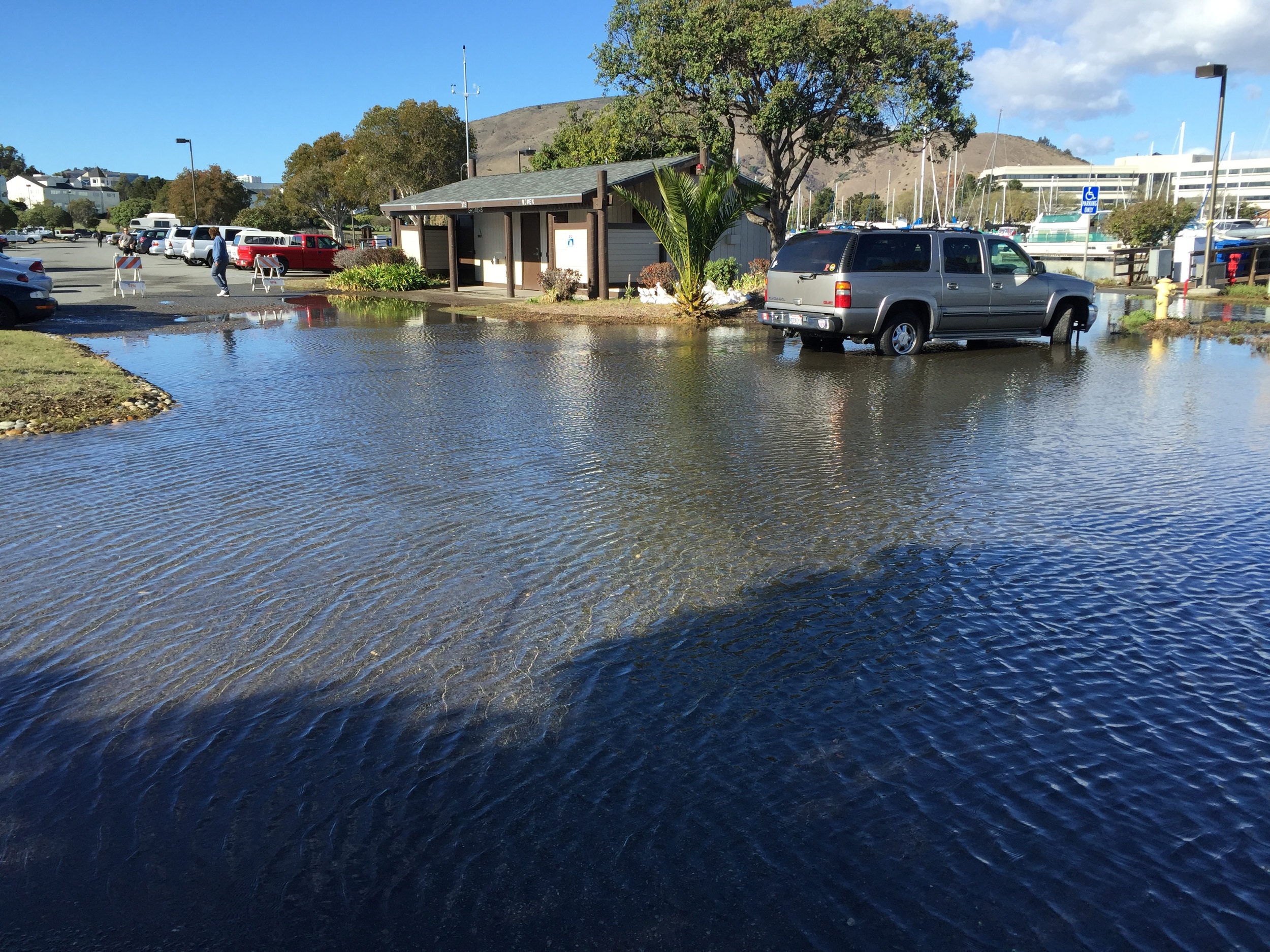
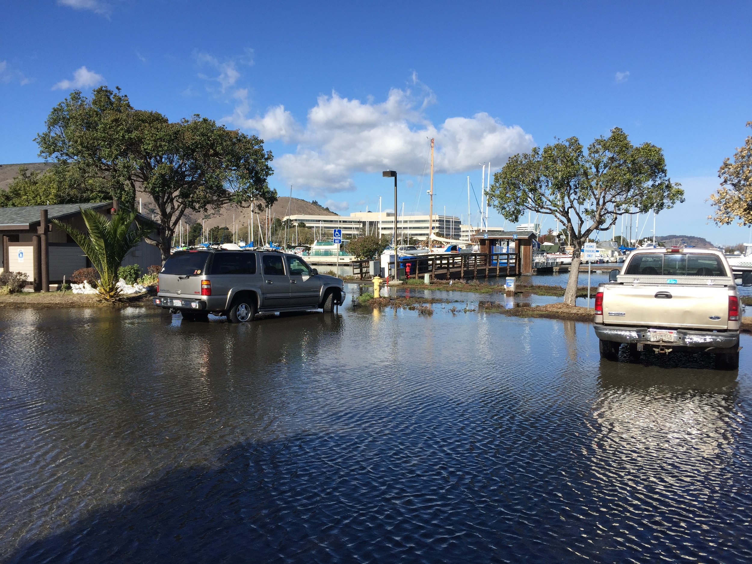
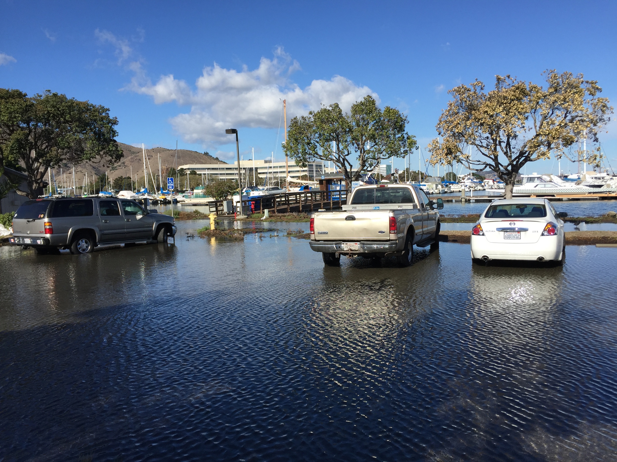
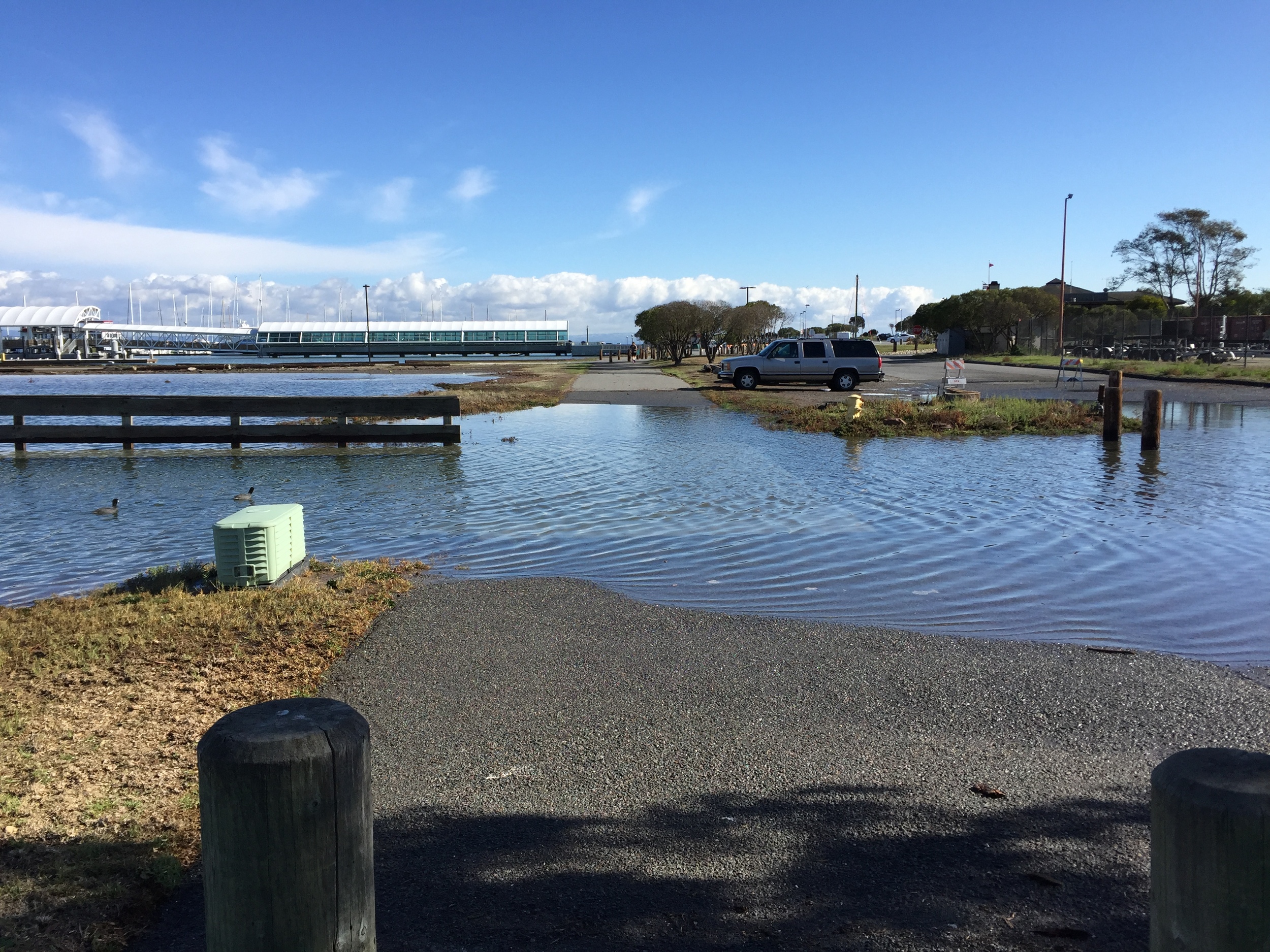
Where is the wisdom in developing such a risky site? Health, safety, and public access concerns include flooding from landfill subsidence and sea-level rise, Bay saltwater breaching the landfill cap, underground electrical saltwater intrusion, gas explosions, and liquefaction.
On Dec. 9, 2015, Bruce H. Wolfe, Executive Officer of the San Francisco Bay Regional Water Quality Control Board sent the City of South San Francisco an enforcement letter regarding recurrent flooding overtopping the landfill cap. The San Francisco Regional Water Quality Control Board, San Mateo County Division of Environmental Health, and Bay Area Air Quality Management District are the agencies that regulate the landfill.
Refer to the following documents for more info:
2000 Water Quality Control Board Updated Waste Discharge Requirements
2010 Hazardous Materials, Oyster Point Specific Plan & Phase 1 Project
Jan 30, 2016 — The SMC Office of Sustainability removed Oyster Point Landfill from the list of recommended assets. The change was disclosed at the County’s SeaChange Open House at Genentech in South San Francisco. The City of South San Francisco informed the County that they would prefer Oyster Point Landfill not be included in the Army Corps of Engineers funded SLR Vulnerability Assessment. The County responded by removing Oyster Point Landfill and replacing it with a landfill located in Half Moon Bay approximately 100 feet above the ocean.
Feb 26, 2016 — City of South San Francisco short-term plan for mitigating flooding at Oyster Point Marina caused by landfill subsidence and sea level rise. See Figure 5 in the Report. It appears that sea-level rise projections have not been calculated or included in the topographical mapping yet.
Oyster Point Landfill, City of South San Francisco, Requirement for Submittal of Technical Reports Pursuant to Water Code Section 13267
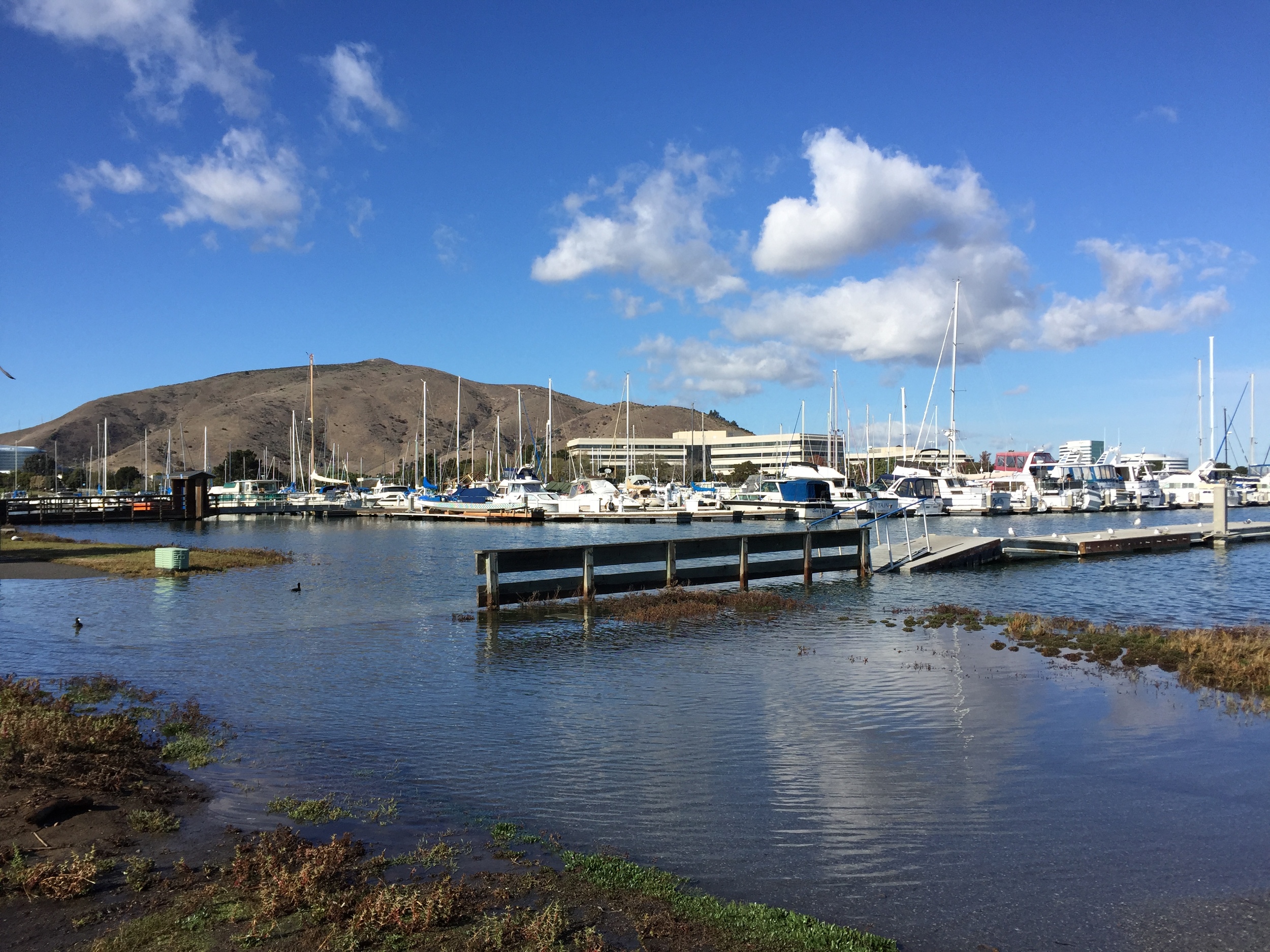
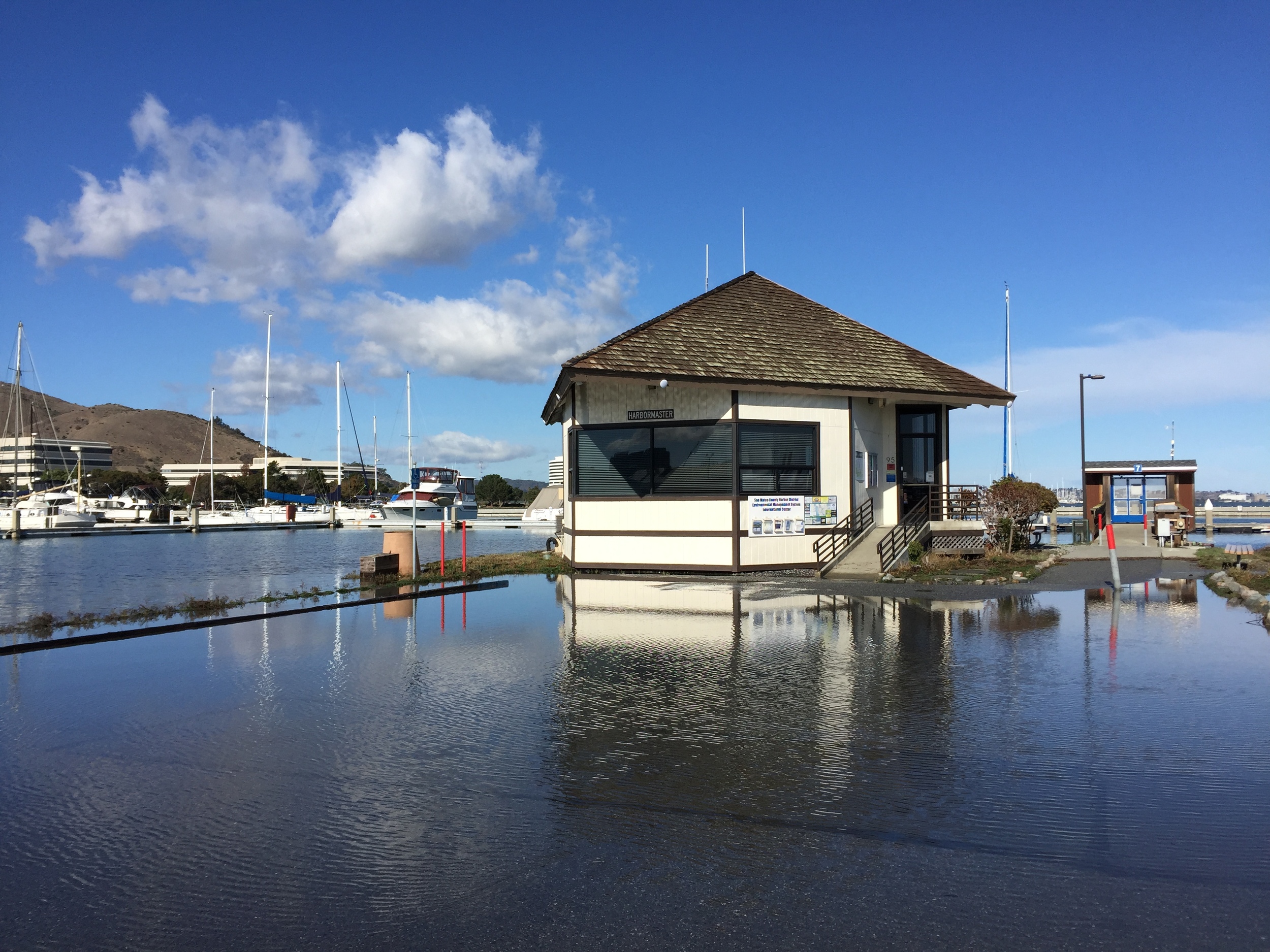
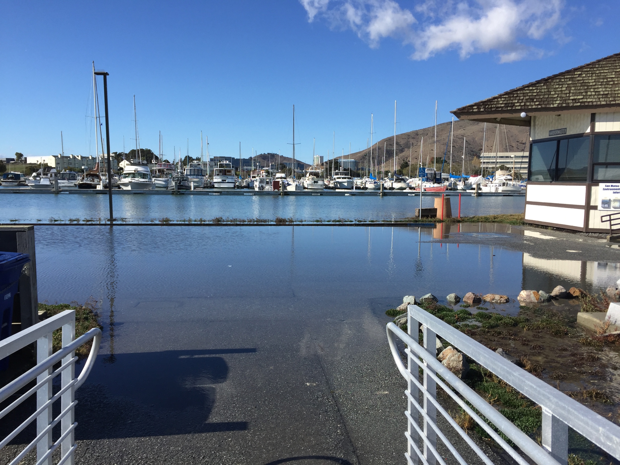
King Tide flooding at Oyster Point Marina—Wed., Nov. 25, 2015
The San Mateo County Harbor District will hold a round table meeting with commercial fishermen to discuss fees.